


Garmin echoMAP 53cv 5"" CHIRP Fishfinder Chart plotter with Transom Mount Preloaded LakeVü Charts
Model: 010-01798-01UPC: 753759176051
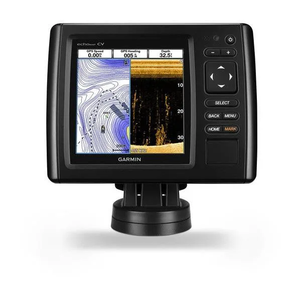
- 5-inch color display with keypad control
- Preloaded LakeVü HD maps cover 17,000 total lakes, of which 13,000 are HD lakes with 1-foot contours shore to shore
- Includes Quickdraw Contours custom HD map creation software
- Internal 5 Hz GPS updates position and heading 5 times per second
- Includes transducer with high wide CHIRP (150-240 kHz) and CHIRP ClearVü (250 W)
It’s time you started fishing with the power of CHIRP sonar. The easy-to-install, easy-to-use 5-inch echoMAP CHIRP 53cv chartplotter includes transducer for high wide CHIRP sonar and Garmin CHIRP ClearVü™ for clear scanning sonar images. It includes Quickdraw Contours software to instantly create your very own HD maps with 1-foot contours as you fish. Internal 5 Hz GPS updates position and heading 5 times per second. Cords plug directly into the mount, allowing you to quickly install and remove your device from power and mount. Transom and trolling motor mounts included.
The built-in sonar capabilities of echoMAP 53cv include CHIRP sonar, the most sophisticated sonar technology available for the fishing and boating public. CHIRP sonar provides amazingly clear target separation and definition because it puts even more energy onto the target than traditional sonar. It also includes sonar-recording capability that coordinates the timing of the sonar return with your boat's position and saves digital information for playback on a computer using HomePort™ planning software. Use the user data sharing cable to share waypoints and routes between multiple devices.
Garmin ClearVü scanning sonar gives you a nearly photographic, wide image of what passes below your boat. You clearly see structure, submerged objects and fish. Traditional Garmin HD-ID™ sonar and ClearVü scanning sonar are combined into 1 transducer. Also provides HD-ID support for Minn Kota® and MotorGuide® trolling motors with integrated transducers.
These highly detailed freshwater maps include 17,000 U.S. lakes, rivers and reservoirs (more than double the number of preloaded lakes of any competitor). That number also includes more than 13,000 HD lakes with 1-foot contours shoreline to shoreline (again, 2 times more than our competition). LakeVü HD gives you excellent detail of underwater features, plus Shallow Water Shading allows you to designate a minimum depth. It also shows interstates, highways, general roads and bridges, designated fishing areas, docks, boat ramps, marinas and campgrounds.
Instantly create personalized HD fishing maps onscreen with 1-foot contours. Tailor them to fit your needs. These are your maps — you own them. Keep the data to yourself, or share it with the Quickdraw Community on Garmin Connect™.
Fast, responsive 5 Hz GPS and GLONASS refreshes your position and heading 5 times each second to make your movement on the screen more fluid. Now it’s quick and easy to drop up to 5,000 accurate waypoints and find your way back to your secret fishing hot spots.
When you’re off the water, it’s easy to keep your echoMAP CHIRP safe and secure. You don’t have to mess with plugging and unplugging wires from the unit because the cords plug directly into the mount. This allows you to quickly install and remove your echoMAP CHIRP from power and the mount.
A single microSD™ card slot provides expandable memory for accessory map purchases, such as LakeVü HD Ultra with Max Def Lakes or BlueChart® g2 Vision® HD, which adds Garmin patented Auto Guidance and other great features.
If you have waypoints, tracks or frequently used routes stored on another manufacturer’s GPS product - or on a Garmin handheld device - it’s easy to transfer those items to your new Garmin chartplotter via industry-standard GPX software formatting.
Auto Guidance is for planning purposes only and does not replace safe navigation operations.
Specifications| Display size | 3.54"" x 3.54""; 5.0"" diagonal |
| Display resolution | 480 X 480 |
| Display type | WQVGA display |
| Water rating | IPX7 |
| Antenna | Internal or external over NMEA 2000 |
| NMEA0183 Compatible | Yes |
| Garmin Marine Network ports | None |
| Maps & Memory | |
| Preloaded maps | LakeVü HD (inland maps) |
| Accepts data cards | 1 microSD™ card |
| Waypoints | 5,000 |
| Routes | 100 |
| Track log | 50,000 points; 50 saved tracks |
| Chartplotter Features | |
| Garmin Sonar compatible | Yes |
| Supports AIS (tracks target ships position) | Yes |
| Supports DSC (displays position data from DSC-capable VHF radio) | Yes |
| Tide tables | Yes |
| BlueChart® Mobile (planning) compatible | No |
| Sonar Features and Specifications | |
| Dual-frequency (50/200 kHz) sonar capable | Yes |
| Dual-beam (77/200 kHz) sonar capable | Yes |
| Transmit power | 500 W (RMS) / 4,000 W (peak to peak) |
| CHIRP sonar technology | Yes, built-in |
| ClearVü | Yes, built-in |
| SideVü™ | No |
| Maximum depth | 2,300 ft @ 77 kHz, freshwater 1,100 ft @ 77 kHz, saltwater (depth capacity is dependent on water bottom type and other water conditions) |
| Bottom lock (shows return from the bottom up) | Yes |
| Water temperature log and graph | Yes |
| Sonar recording | Yes |
| Sonar history rewind | Yes |
| Connections | |
| NMEA 0183 input ports | 1 |
| NMEA 0183 output ports | 1 |
| Video input ports | None |
| Video output ports | None |
| Wireless connectivity | No |
| NMEA2000 | Yes |
| Dimensions | 6.8"" x 5.4"" x 1.7"" (17.3 x 13.6 x 4.4 cm) |
What's in the Box:
- echoMAP CHIRP 53cv
- Power/data cable
- Tilt/swivel mount
- Flush mount
- Documentation
- Protective Cover
- Hardware
- Transducer (4-pin)
- NMEA 2000 adapter cable (4-pin Female to 5-pin Male)
- Transom mount


")

 3500K N1 SIDE W/2 MOLDED INPUTS L-N1-12V3WM-35K-5M-1")

")


